
Image
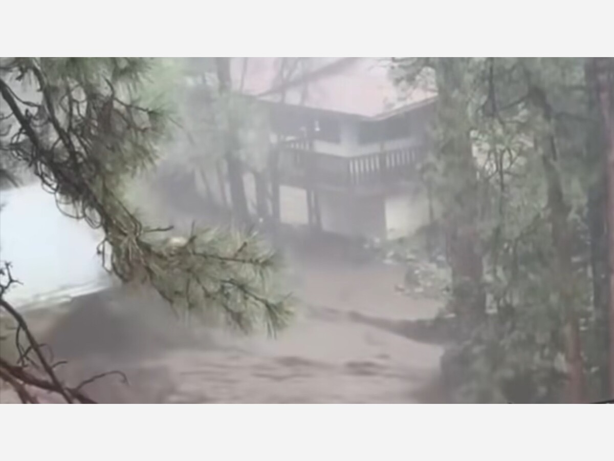

The National Weather Service has issued flash flood watch and a high wind advisory for Southern and Central New Mexico until 9 pm on Wednesday.
Expect potential winds up to 35 mph with random gusts up to 75 mph. At 5:00 pm in Alamogordo random gust hit 62 mph with mountainside lightening.
In the mountain communities including Riudoso, Cloudcroft etc are experiencing light rainfall with heavy lightning and thunder after coming out of historic rain and mud levels on Tuesday. Citizens should be tied to their phones and radio's listening for emergency alerts for the mostbup to date information.
The inpact of Wednesdays rains were minimal as massive cleanup continues in Ruidoso were about 50 homes were destroyed and FEMA Helicopters were mapping the damage.
a useful thought from reports regarding the texas hill country's devastating floods;
"Floodplain maps are based on historical data. They don't reflect the current - or future - risk. It's backward-looking in a forward-moving crisis."
— Robert Mace, a hydrologist and executive director of the Meadows Center at Texas State University, on the dangers of flooding in the Hill Country.
Robert Mace apparently doesn't know his job very well, which is to produce maps that show future risk.
No single point in the area recorded a record rainfall, which in my estimation based on geographic location in relation to weather patterns and historic rainfall could be as much as 3 times or more than the amount of rain that fell last weekend. And that's just based on historic rainfall, not cockamamie climate change.
The job of a Hydrologist is to calculate how much rain an area could get, what the topology is, what the soil consists of, and what vegetation is there. From that info it's possible to tell how much water will be absorbed over a given length of time, and how much will runoff, as well as where it will run to. That info can then be used to generate a map showing potential flooding for any given amount of rain over any given time frame.
His job.
This event had nothing to do with any climate change, man made or otherwise, it was simply a storm that fell on a bad area. It didn't produce record rainfall, or record rainfall rates. It didn't cover a larger area than previous storms. It happened to cover more of a flood prone area than storms over the last few decades, but that was by chance, not change.


Patchy rain nearby, with a high of 102 and low of 76 degrees. Sunny in the morning, clear in the afternoon and evening,

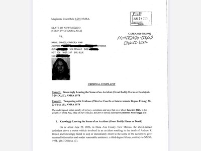
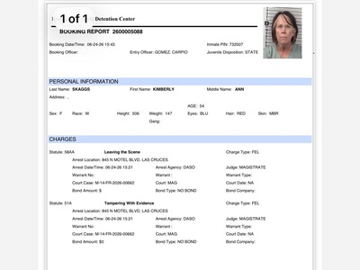
I'm baffled and disturbed as to the missing vehicular homicide charge (legal term for vehicular manslaughter in NM).
took the REUBLICON Police TWO Days to charge and arrest her.....plenty of time for the GOP to fire her and cover her tracks for her.....WHY????.....if that was a NOBODY Citizen they would have tracked them and arrested them within an HOUR....but guess what?....how much you want to bet she gets a PARDON from Donald t
RepubliCON Police
the smartest maintenance expenditures are spent looking to the future, not repairing the past. kudos for the forward thinking/planning, hope it bears fruit.


Hmm. Elected city officials making comments “as a private citizen”. A trend that started with former city officials here and is reminiscent of lawsuits going on in Los Angeles right now.

While Mr. Stockwell may hit the ground running, why is the public not asking how complicit he was in the tainted hiring process? He is a past city manager; he knows about hiring protocols. Why didn't he ask the commission to be transparent?

just another law and order political personality who believes they should be exempt for those laws...
Remember when they all ran from sniper fire. At this point, what does it matter.