Image
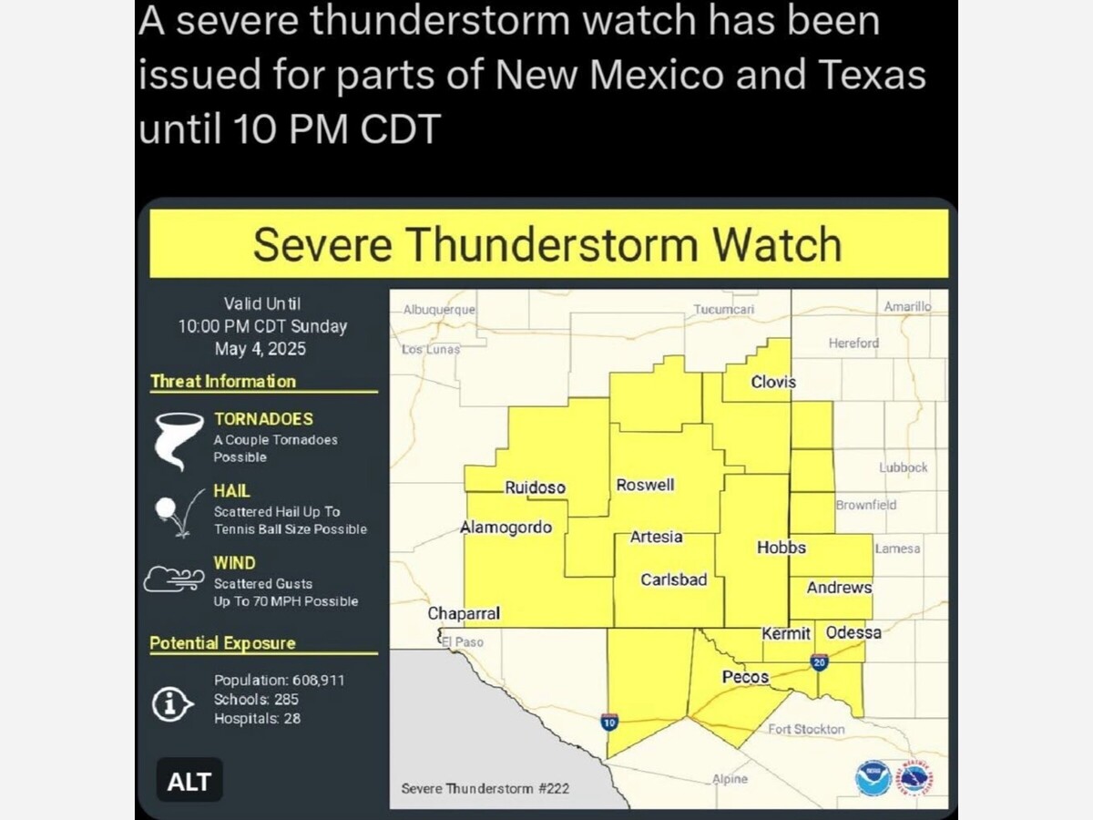

The National Weather Service has issued a severe thunderstorm watch until 9 pm.
The impacted counties in New Mexico are Chaves,Curry, De Baca, Eddy, Lee, Lincoln, Otero and Roosevelt.
Know the difference between a National Weather Service Severe Thunderstorm Watch and a Severe Thunderstorm Warning.
With a Severe Thunderstorm Watch: Be Prepared! Severe thunderstorms are possible in and near the watch area. Stay informed and be ready to act if a severe thunderstorm warning is issued. The watch area is typically large, covering numerous counties or even states.
A Severe Thunderstorm Warning means to Take Immediate Action!
Severe weather has been reported by spotters or indicated by radar. Warnings indicate imminent danger to life and property. Take shelter in a substantial building. Get out of mobile homes that can blow over in high winds. Warnings typically encompass a much smaller area (around the size of a city or small county) that may be impacted by a large hail or damaging wind identified by an NWS forecaster on radar or by a trained spotter/law enforcement who is watching the storm.
What Constitutes a Severe Thunderstorm?
To people who follow weather on a regular basis, this might seem like a silly question, but to others who are not regular weather watchers, the question of what constitutes a Severe Thunderstorm is an important one. The concern we have at the National Weather Service is, if the folks do not know what one is, they are less likely to take heed of its dangers. The following is important information that everyone needs to know, including the definition of a Severe Thunderstorm.
Some tips from the NWS...
In order for a thunderstorm to be considered severe, it must create at least one of the following:
Hail that is one (1) inch in diameter or larger
Winds of 58 miles per hour (mph) or greater
Now, some folks might say to themselves, "58 mph? That's nothing!
But here's the problem: 100 mph winds going in a straight line (such as would come out of a thunderstorm) or rotating in a circle (such as in a tornado) are still 100 mph winds. They are still capable of knocking down trees, which can fall on homes, power lines, cars and people! So, to the NWS they are just as dangerous as tornadoes! Plus, any thunderstorm inherently has lightning in it. It can't be a thunderstorm without it. So there are many characteristics of a thunderstorms that are dangerous.
Lightning is one of the most dangerous aspects of a thunderstorm. Lightning can strike up to 10 miles from the main area of the thunderstorm. That is about the distance you can hear thunder from the storm. Whether or not you can see the actual lightning flash, if you can hear thunder, you are at risk of being struck. Because of this, the National Weather Service has adopted the following the motto, “When Thunder Roars, Go Indoors . . .and stay there at least 30 minutes after the last clap of thunder.” See these Lightning Safety tips for more info.
Like the NWS tornado warnings, severe thunderstorm warnings are Storm Based Warnings, which means they issue a polygon shaped warning for either an individual storm, or a line of storms. They are issued normally for 30-60 minutes at a time and look like this. Each warning will alert on NOAA Weather Radio and typically through local media.


Sunny, with a high of 82 and low of 54 degrees. Sunny for the morning, clear in the afternoon and evening,


Johnathans mom would be happy her sons killers were convicted. May she RIP.