
Image

An investigative report on restricted land, response times, staffing realities, and a department under mounting legal siege.
The Number That Gets Cited — And What It Actually Means
Ask officials at the Otero County Sheriff’s Office why emergency response times in communities like Chaparral can stretch to 20 minutes or longer, and you will reliably hear a version of the same answer: the department is responsible for patrolling one of the largest counties in the state, covering thousands of square miles of rugged terrain. The implied message is that geography alone explains the gap between a 911 call and a deputy’s arrival.
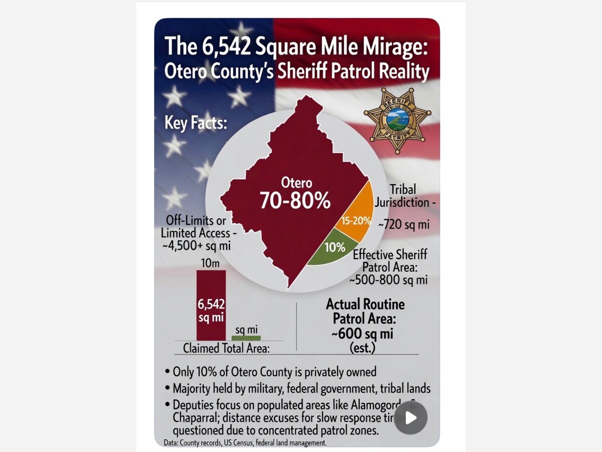
The number those officials lean on is approximately 6,542 to 6,627 square miles — the county’s total land area. According to the U.S. Census Bureau, Otero County has a total area of 6,628 square miles, of which 6,613 square miles is land. It is the third largest county in New Mexico and the 35th largest in the United States.
Those numbers are accurate. What they are not is honest — at least not as commonly used in public discussions about service levels. Because the hard, verifiable truth is that the vast majority of that land is off-limits to county sheriff’s deputies. Understanding what is actually patrollable, why the gap matters, and how Otero County’s performance compares to peer counties requires pulling back the curtain on one of the most convenient excuses in local government.
Who Actually Owns Otero County?
The single most important fact in any honest discussion of the Otero County Sheriff’s patrol capacity is this: only 10% of Otero County’s land area is privately owned. The federal government, the Mescalero Apache Tribe, and the State Land Office own the remaining 90%.
That is not a minor caveat. It is the defining feature of the county’s geography — and it renders the headline figure of 6,600+ square miles nearly meaningless as a measure of sheriff’s patrol burden.
White Sands Missile Range: The Largest Off-Limits Zone
White Sands Missile Range (WSMR) is a United States Army rocket range of almost 3,200 square miles across parts of five counties in southern New Mexico — the largest military installation in the United States. It spans parts of Doña Ana, Otero, Sierra, Socorro, and Lincoln counties.
WSMR does not reside solely in Otero County. Its main cantonment and headquarters sit in Doña Ana County near Las Cruces. Cartographic and geographic analysis places roughly 800 to 1,000 square miles of WSMR’s footprint within Otero County’s boundaries, concentrated in the western Tularosa Basin. White Sands Missile Range, Holloman Air Force Base, and the Fort Bliss Military Reservation are all in western Otero County. Every square mile of WSMR within Otero County is closed to civilian law enforcement without specific military authorization.
White Sands National Park — covering approximately 228 square miles across Otero County and Doña Ana County — has been completely surrounded by military installations since 1941, with no routine county law enforcement role.
Holloman Air Force Base: ~93 Square Miles of Federal Territory
Holloman Air Force Base covers 59,639 acres — approximately 93 square miles — and supports about 21,000 active duty personnel, Guard and Reserve members, retirees, and their families. The base is located six miles southwest of the central business district of Alamogordo. The base has its own security forces and federal jurisdiction. Otero County sheriff’s deputies have no routine patrol role within its perimeter.
The Mescalero Apache Reservation: ~720 Square Miles of Sovereign Land
The Mescalero Apache Indian Reservation covers 720 square miles of land in Otero County, running 27 miles from north to south and 36 miles from east to west at its widest point. The 463,000-acre reservation lies on the eastern flank of the Sacramento Mountains and borders the Lincoln National Forest.
As sovereign tribal land, the reservation is governed by its own tribal law enforcement authority. The Otero County Sheriff’s Office holds no primary jurisdiction there. Mutual aid arrangements may occasionally bring county deputies to the reservation in extraordinary circumstances, but day-to-day patrol responsibility belongs to the tribe.
Lincoln National Forest: Over 1,700 Square Miles Total, Substantial Portion in Otero
The Lincoln National Forest encompasses 1,103,897 acres (approximately 1,725 square miles) across parts of Chaves, Eddy, Lincoln, and Otero counties. The forest’s northern portion is divided into two ranger districts — the Sacramento and Smokey Bear districts — separated by the Mescalero Apache Reservation.
The Sacramento Ranger District, headquartered in Cloudcroft, covers the southern Sacramento Mountains east of Alamogordo — deep within Otero County. The Otero County share of the Lincoln National Forest is estimated at between 600,000 and 700,000 acres (roughly 940 to 1,100 square miles). While federal forest land is not formally closed to county law enforcement, the U.S. Forest Service holds primary jurisdiction for law enforcement within national forest boundaries. Because substantial portions of Otero County’s land area fall under federal jurisdiction, the county government exercises limited direct authority over those areas. Sheriff’s deputies respond to serious incidents in the forest under mutual aid, but it is not a routine patrol zone.
Fort Bliss / McGregor Range: Southern Otero Mesa
WSMR and the 600,000-acre McGregor Range Complex at Fort Bliss form a contiguous swath of territory for military testing, with the McGregor complex occupying the southeastern Tularosa Basin on Otero Mesa. An estimated 200 to 300 square miles of this complex touches southern Otero County. It is entirely inaccessible to civilian law enforcement.
The Real Numbers: Constructing an Honest Patrol Map
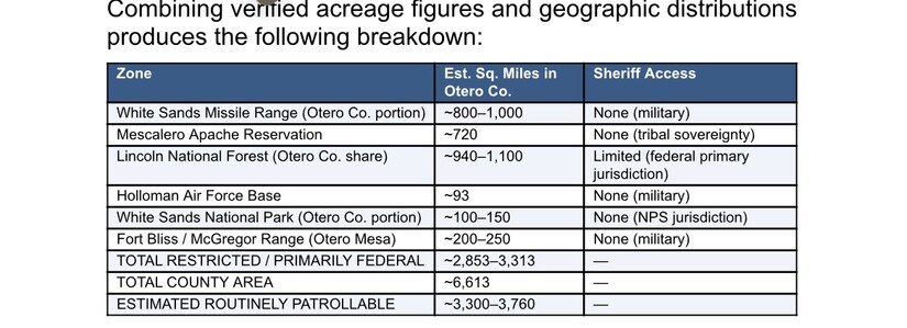
Even the 3,300–3,760 square mile remainder overstates the practical patrol area. Much of what remains outside military and tribal zones is state trust land, rugged desert, and remote mountain terrain with limited road access. When factoring in only land where routine, day-to-day patrols are realistically concentrated — private land, populated unincorporated communities, and accessible state-trust corridors — the effective daily patrol footprint shrinks further.
KEY FINDING: A department routinely citing 6,542 square miles of territory may be actively patrolling as few as 500–800 square miles of routinely covered ground on any given day — less than 10% of the figure cited to the public.
The Staffing Picture
The Otero County Sheriff’s Office lists 39 sworn deputies and a total of 62 staff members serving a county of roughly 70,000 residents. Even on a 24/7/365 rotation with standard three-shift scheduling, that means no more than 10 to 15 deputies are on active duty at any given time across the entire county — including Alamogordo, Chaparral, the mountain communities, and all highway corridors.
The Sheriff’s Office maintains sub-stations in Cloudcroft and Chaparral in addition to its main headquarters in Alamogordo. That three-location structure is designed precisely to reduce response times by stationing deputies closer to geographically dispersed communities. The Chaparral substation in particular exists because Chaparral — located roughly 70 miles from Alamogordo near the Texas border — generates a significant and growing call volume.
In January 2026 alone, Chaparral deputies handled 64 investigative reports and 11 arrests, while responding to 105 animal-related calls, underscoring the area’s ongoing demand for law enforcement services.
The existence of a Chaparral substation fundamentally undermines the “20 minutes due to distance” narrative. If a deputy is on shift and stationed in Chaparral, an emergency call within that community should receive a response in minutes — not 20. When response times exceed 20 minutes in Chaparral, the question is not about geography. It is about whether a deputy was on duty at the substation, whether they were engaged elsewhere, or whether staffing levels left the substation empty. Those are resource allocation and management decisions — not acts of geography.
In November 2025, the Otero County Sheriff’s Office received a $570,000 federal grant from the U.S. Department of Justice aimed at expanding patrol coverage and enhancing response times by hiring additional deputies and strengthening training in de-escalation and crisis intervention. The grant itself is an implicit acknowledgment that the department was under-resourced — but the solution being funded is staffing, not geography. The department itself acknowledges navigating “budget constraints and staffing challenges common to rural law enforcement agencies.” That is a far more honest characterization than citing raw square mileage.
Comparing Peer Counties: Context That Exposes the Gap
When comparing deputies-per-patrollable-square-mile rather than deputies-per-nominal-square-mile, Otero County’s operational coverage deficit becomes even more apparent — and the “vast territory” justification for slow response times loses much of its force.
A Department Under Legal Siege
While geography narratives deflect accountability questions, the Otero County Sheriff’s Office has accumulated a legal and financial crisis in recent years that demands direct examination.
The Elijah Hadley Shooting — A $5–10 Million Exposure
In June 2024, 17-year-old Elijah Hadley, a Mescalero Apache Tribe member, was fatally shot by then-Deputy Jacob Diaz-Austin during a welfare check on U.S. Highway 70. Diaz-Austin fired 19 shots after Hadley tossed away a realistic-looking airsoft gun. In January 2025, first-degree murder charges were filed against the deputy, with a trial delayed to August 2026. The civil wrongful-death lawsuit, filed in June 2025, seeks damages potentially exceeding $5–10 million.
The lawsuit, filed in U.S. District Court in Albuquerque, names both Deputy Diaz-Austin and the Otero County Board of Commissioners, alleging violations of the Fourth and Fourteenth Amendments and New Mexico state civil rights laws. According to the filing, evidence shows Hadley tossed the BB gun into the grass when ordered to show his hands and never threatened or pointed the gun at the deputy.
The Jacob Gutierrez Detention Death — $2 Million Settlement
In February 2026, Otero County agreed to pay over $2 million to the family of Jacob Gutierrez, a 26-year-old inmate who took his own life in 2023 after multiple suicide attempts that allegedly went unaddressed by jail staff and the facility’s healthcare provider, Vital Core. Attorneys noted the settlement’s size reflected the severity of the constitutional oversight failures alleged.
A Second Civil Rights Case — Mental Health Crisis Response
In a separate case, attorneys filed a federal civil rights lawsuit alleging that Otero County Sheriff’s deputies responded to a man experiencing a mental health crisis and escalated the situation with aggressive tactics — including the use of a flashbang grenade — ultimately shooting him while he was holding a screwdriver. The complaint brings claims under both 42 U.S.C. § 1983 and the New Mexico Civil Rights Act, which expressly eliminates qualified immunity as a defense for government employees who violate constitutional rights.
The Dispatch Authority Collapse
The 2025 dissolution of the Tularosa Basin Regional Dispatch Authority — formed in 2021 under a joint powers agreement — followed Alamogordo’s 4-3 vote to withdraw amid allegations of operational deficiencies, governance disputes, canceled oversight meetings, and safety concerns, resulting in over $2 million in lost revenues for the county. Dispatch coordination is foundational to response times. Its collapse directly affects the very service-level questions residents are raising.
Financial Reckoning: The Bill Is Coming Due
Otero County Commission and County Executive officials are grappling with a potential financial crisis as costly settlements, ongoing litigation, and recent policy shifts threaten to drain millions from the county’s coffers.
Legal observers note that repeated federal filings naming county facilities — whether local-jail civil-rights suits or immigration habeas actions — erode public and insurer confidence, potentially raising future premiums and borrowing costs for a rural county of just 70,000 residents.
The scale of legal exposure is extraordinary for a county this size: a $2 million detention settlement already paid, a $5–10 million wrongful-death lawsuit pending, a second civil rights case in federal court, a deputy facing first-degree murder charges, and a collapsed regional dispatch authority — all within roughly 24 months.
Additionally, the FY 2021–2022 county audit identified discrepancies in detention facility invoices resulting in overpayments ranging from $470,000 to $2.5 million, and noted noncompliance with late submission of required financial reports. State oversight is expected to intensify in the coming fiscal year.
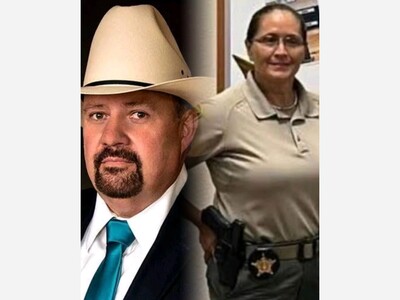
The 2026 Sheriff’s Race: Accountability on the Ballot
The 2026 race for Otero County Sheriff has intensified in the shadow of outgoing Sheriff David Black’s controversial tenure and a deep rift within the local Republican Party. With two declared Republican candidates vying for the office, the election has become a referendum on continuity versus accountability, with the fatal 2024 shooting of Elijah Hadley, ongoing allegations of cronyism, and political infighting at the heart of the debate.
The Sheriff’s Reserves — a group of trained volunteers who help support the department when shifts are under-staffed — are regularly called upon to back up deputies during low-manning situations, large emergencies, and major crime scenes. The reliance on volunteers to fill patrol gaps is itself an indicator of chronic understaffing, not simply a function of geographic scale.
Facts vs. Fiction: A Clear-Eyed Summary
Fiction: The Otero County Sheriff’s Office patrols 6,542 square miles, making slow response times understandable and largely unavoidable.
Fact: With only 10% of Otero County privately owned, and with military installations, sovereign tribal land, and federal forest consuming the overwhelming majority of the county’s area, the realistic routine patrol territory is estimated at 500 to 800 square miles of actively covered ground — possibly less than 10% of the figure routinely cited. Using the total county area to justify service gaps is, at best, misleading.
Fiction: Twenty-minute response times in Chaparral are a product of distance.
Fact: The Sheriff’s Office operates a dedicated substation in Chaparral. Response time failures in that community are a function of staffing levels, shift coverage, and management decisions — not raw miles.
Fiction: The department’s legal troubles are typical for a rural New Mexico agency.
Fact: Two federal civil rights lawsuits, a $2 million detention death settlement, a sitting deputy facing first-degree murder charges, and a collapsed regional dispatch authority within a 24-month window is not normal. It is a systemic crisis demanding structural reform.
The communities of Otero County — from Alamogordo to Chaparral, from Cloudcroft to Tularosa — deserve a law enforcement agency that accounts honestly for what it can and cannot cover, allocates resources where people actually live, and holds itself accountable to the same standards it asks of the public. Square mileage is not accountability. It is arithmetic.
Sources: NM Counties Association, U.S. Census Bureau, U.S. Army/White Sands Missile Range official records, Holloman AFB data, U.S. Forest Service/Lincoln National Forest, U.S. Department of Transportation/Mescalero Apache Tribal records, Border Sheriffs Association, Doña Ana County Sheriff’s Office, 2nd Life Media Alamogordo Town News, New Mexico Conservative News, New Mexico Government Authority, Fayerberg Dodd Law Offices, KTSM 9 News, U.S. District Court for the District of New Mexico.
Now, with the mud slinging on social media by relatives of Sheriff Black it’s time for regime change. Maybe a qualified, experienced law enforcement leader who is also a veteran is what is needed.


Sunny, with a high of 103 and low of 76 degrees. Sunny during the morning, clear for the afternoon and evening,


Congrats to SHERIFF YAZZA!

Thanks for being on top of this, in light of all the other problems at the County: namely the state auditors findings and Project Jupiter. Both are indicative to me that a new County Manager won't resolve the long-term tightly woven ball of problems this county has, including the Commissioners themselves. I've got