
Image
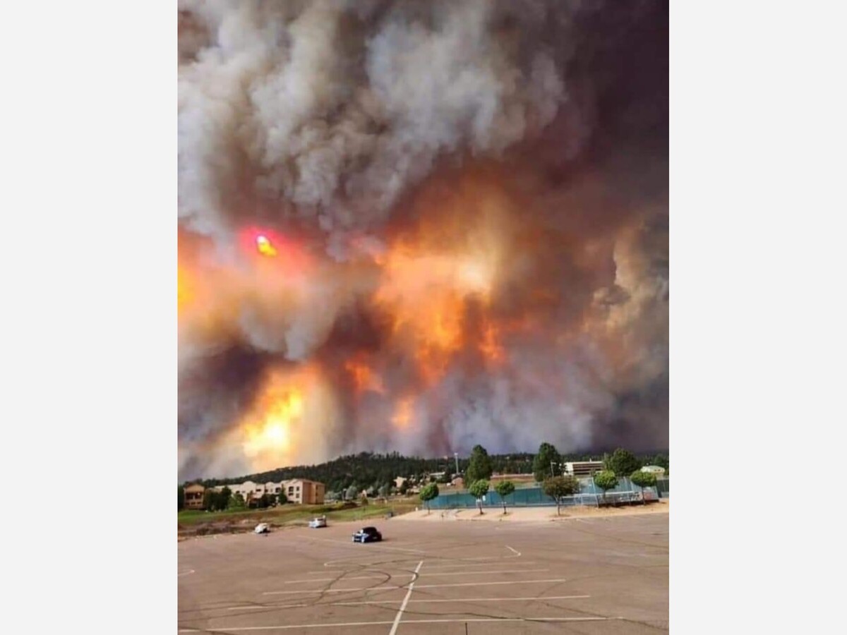
Village of Ruidoso by Lincoln County Sheriff’s Dept

The South Fork Fire and Salt Fire on the Mescalero Apache Indian Reservation, spanning Otero and Lincoln Counties is an active fire and moving fast. An immediate evacuation order was issued for the entire Village. Go Now issued at 7:38 pm on Monday, per the authorities of the Village of Ruidoso.
The South Fork Fire ignited Monday morning on Mescalero Apache tribal land and had exploded to at least 3,000 acres by nightfall.
The South Fork Fire and the Salt Fire are burning on Mescalero tribal land, US Forest Service land, and the area surrounding Ruidoso. Both fires are being managed by Mescalero Apache Fire Rescue and Bureau of Indian Affairs. Complex Incident Management Teams are on order.
Residents of the Village of Ruidoso are under an emergency mandatory evacuation order due to wildfires in the area.
The South Fork Fire and the Salt Fire are burning on Mescalero tribal land, near Ruidoso, according to the New Mexico Forestry Division.
Per New Mexico Fire; the South Fork Fire is currently estimated at 5,252 acres and zero percent containment. Fire activity is expected throughout the night due to winds and low relative humidity. Multiple structures are under threat, and unknown number of structures have been lost. 10 Type-1 Hotshot crews are on scene or en route. Tomorrow the incident will be transferred to a Complex Incident Management Team.
The South Fork Fire was discovered at 9 a.m., Monday, June 17, 2024; it is burning on Mescalero Tribal land, US Forest Service land and within the areas surrounding Ruidoso. Fire growth has been rapid with extreme fire behavior. Long range spotting and intense heat with plume domination. The cause of the fire is under investigation.
Village of Ruidoso is under mandatory evacuation. US 70 is closed from mm 249 (intersection NM 244), 4 miles east of Mescalero, to mm 258, 2 miles east of Carrizo. The only available evacuation route is on Sudderth to Highway 70, leading out to Roswell.
An Evacuation Center at Eastern New Mexico University-Roswell is available at 52 University Blvd, Roswell, NM 88203 gym. People with livestock and RVs can head to the Eastern New Mexico state fairgrounds at 2500 SE Main St, Roswell, NM 88203.
Community Resources: Emergency Operations Center is now operational. For information or assistance regarding the South Fork Fire or other emergencies, please call 575-258-6900.
Residents and visitors who want to voluntarily evacuate can now seek shelter at Capitan High School at 519 Smokey Bear Blvd., Capitan, NM 88316. The Ruidoso Convention Center is not taking any more evacuations, and those that are there will shelter in place should the status at the Convention Center change.
Pets to Humane Society of Lincoln County: Address: 25962 US-70, Ruidoso, NM 88345
Mescalero Evacuations: The Tribe’s evacuation center for Reservation residents is at the Community Center Gymnasium.
Incident Map URL: https://www.arcgis.com/apps/mapviewer/index.html?webmap=e2c6d99f914c44cbb18b75e73beef035
More information about shelters and evacuations can be found here: https://www.facebook.com/villageofruidoso
https://www.facebook.com/mescaleroapachetribe
Shelters:
Inn of the Mountain Gods, for tribal or non-tribal persons —
287 Carrizo Canyon Rd., Ruidoso NM
In Roswell:
ENMU-R Gymnasium
52 B University Blvd
Church on the Move
901 W. Brasher
NMMI Godfrey Center
101 W. College
NM Dream Center
2700 W. Second Street
ENM Fairgrounds
RVs and Large Animals
2500 SE Main
Roswell Convention Center
900 N. Main
Roswell Aquatic Center
1500 W. College
Acres: 5,252 estimated
Start Date/ Time: June 17, 2024; 9 a.m.
Cause: Under investigation
Location: Rio Ruidoso, west of the Upper Canyon area of Ruidoso
Ownership: Tribal
Structure Threat: Multiple structures threatened; unknown structures lost
Resources: Bureau of Indian Affairs, Mescalero Apache Fire Rescue, US Forest Service, multiple aviation assets, local resources, a Complex Incident Management Team is on order for Tuesday. June 18.
Containment: 0%
Fuels: Mixed conifer
Salt Fire
Location: Mescalero Reservation, Otero County, Southwest of Ruidoso
Size: 2,815 acres
Containment: 0%
Resources: BIA, Mescalero, US Forest Service, multiple aviation assets
Fire Activity: Active
Evacuations: Evacuation orders will remain in effect overnight for: Chatto Bluff, Apache Summit, Fantasy Lane, homes along Highway 70 from Highway 244 to the east Reservation line, Bear Canyon, and Snow Canyon.
Interactive Map
https://mappingsupport.com/p2/gissurfer.php?center=33.346166,-105.67440…
Otero & Lincoln County Fires - Albertsons Ruidoso Manager
https://youtu.be/E26o_4CBpt8
Otero & Lincoln County Fires - Anthony Torres Mountain View Church
https://youtu.be/vF_alaOx1N0
Otero & Lincoln County Fires - Mayor Craig Turner - Cloudcroft
https://youtu.be/q6i2kGWXf2
Otero & Lincoln County Fires - Mayor Susan Payne - Alamogordo
https://youtu.be/xACMTAWV_pw
Otero & Lincoln County Fires - Mayor Debbie Cooksey - Tularosa
https://youtu.be/iJB6pOyzLkg
Otero & Lincoln County Fires - Mayor Susan Payne - Alamogordo
https://youtu.be/xACMTAWV_pw


Sunny, with a high of 87 and low of 57 degrees. Sunny in the morning, clear for the afternoon and evening,


Awesome work! Now do Desperado Gabe Sanchez